


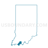
CLAY 03, Spencer County, Indiana
About
Outline

Summary
| Unique Area Identifier | 580627 |
| Name | CLAY 03 |
| County | Spencer County |
| State | Indiana |
| Area (square miles) | 1.88 |
| Land Area (square miles) | 1.81 |
| Water Area (square miles) | 0.07 |
| % of Land Area | 96.21 |
| % of Water Area | 3.79 |
| Latitude of the Internal Point | 38.10816140 |
| Longtitude of the Internal Point | -86.95244150 |
Maps


Graphs
Select a template below for downloading or customizing gragh for CLAY 03, Spencer County, Indiana


Neighbors
Neighoring Voting District (by Name) Neighboring Voting District on the Map
- CARTER 01, Spencer County, IN
- CARTER 03, Spencer County, IN
- CLAY 01, Spencer County, IN
- CLAY 02, Spencer County, IN